Downloads
DOI:
https://doi.org/10.58981/bluepapers.2025.1.12Published
Issue
Section
License
Copyright (c) 2025 Roeland Emaus, Sylvia Leenaers

This work is licensed under a Creative Commons Attribution 4.0 International License.
How to Cite
Keywords:
data, land use, land subsidence, photogrammetry, water managementAbstract
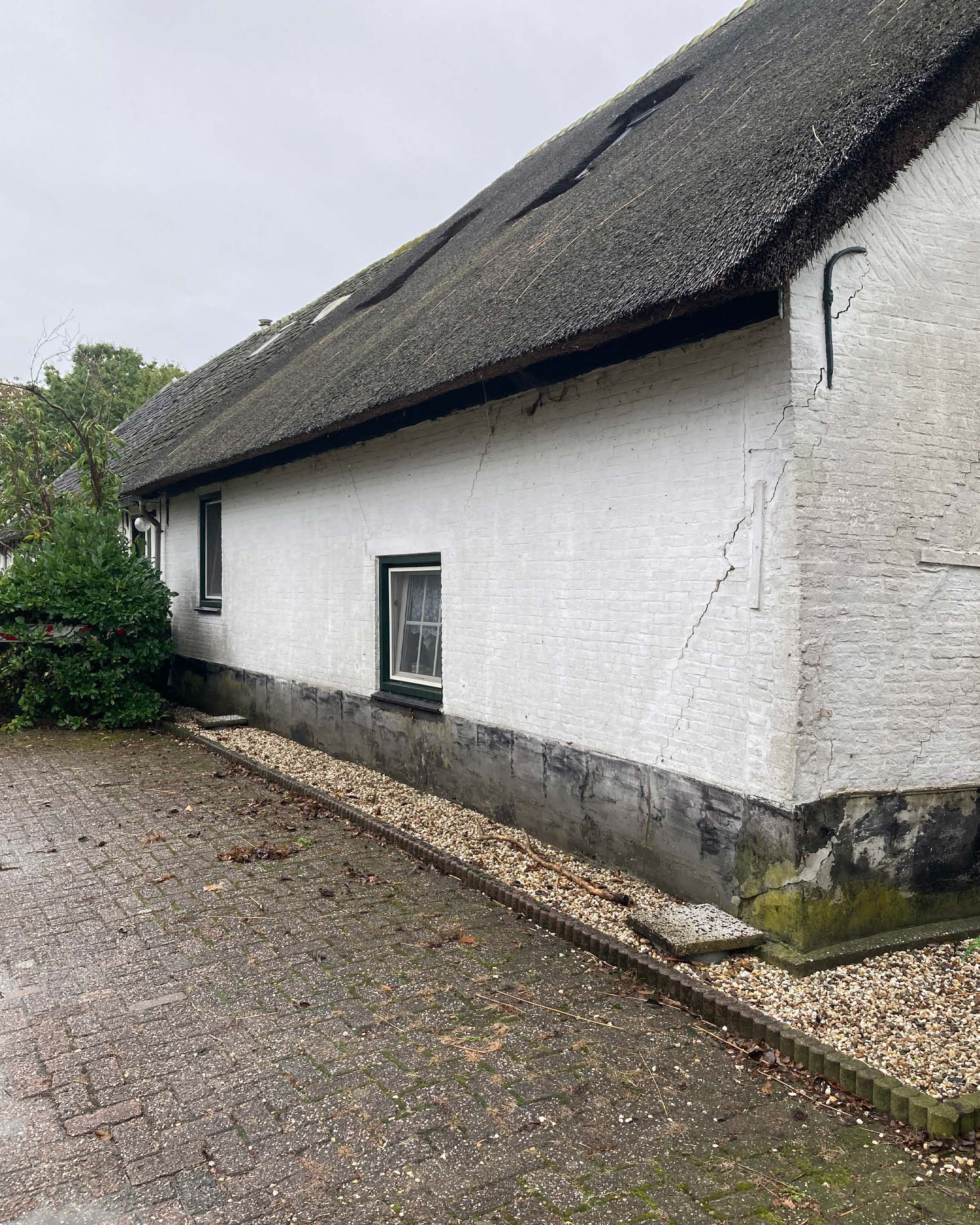
The region surrounding Gouda, in the middle of the Dutch Delta, is one of the lowest-lying areas in the Netherlands. The historic inner city is situated at the current high-water mark (Amsterdam Ordnance Datum, or NAP). In contrast, the surrounding landscape lies between two and six meters below that due to subsidence as a result of draining the land and making it available for urbanization and agriculture. The original factors that caused the land to subside are still at play here, while relative sea level rise adds to the problem by making these areas prone to flooding. In this region, accurate digital terrain models make an invaluable contribution to data-driven governance and decision-making. These models can illuminate how changing conditions affect heritage sites and the cultural landscape. We propose and evaluate a methodology for developing accurate terrain models from historical aerial photographs. The method provides high-density, high-precision data for the past half-century. This data can provide insight into the long-term effects of local interventions on local subsidence, making the method a valuable tool for developing risk inventories for proposed interventions.
References
Asselen, Sanneke van, Gilles Erkens, and Francis de Graaf. 2020. "Monitoring Shallow Subsidence in Cultivated Peatlands." Proceedings of the International Association of Hydrological Sciences 382:189–94. https://doi.org/10.5194/piahs-382-189-2020
Asselen, Sanneke van, Gilles Erkens, Esther Stouthamer, Hessel A. G. Woolderink, Rebecca E. E. Geeraert, and Mariet M. Hefting. 2018. "The Relative Contribution of Peat Compaction and Oxidation to Subsidence in Built-up Areas in the Rhine-Meuse Delta, The Netherlands." Science of the Total Environment 636: 177–91. https://doi.org/10.1016/j.scitotenv.2018.04.141
Avery, T. Eugene. 1968. Interpretation of Aerial Photographs. 2nd ed. Burgess Publishing Company.
Cosgrove, Denis, and William F. Fox. 2010. Photography and Flight. Reaktion Books.
Koomen, A. J. M., and R. P. Exaltus. 2003. De Vervlakking van Nederland; Naar Een Gaafheidkaart Voor Relief En Bodem [The flattening of the Netherlands; towards a coolness card for relief and bottom]. Alterra. https://edepot.wur.nl/24437
Locher, W. P., and H. de Bakker. 1990. Bodemkunde van Nederland: Algemene bodemkunde [Soil science of the Netherlands: General soil science]. Malmberg.
Stouthamer, Esther, Gilles Erkens, Kim Cohen, Dries Hegger, Peter Driessen, Hans Peter Weikard, and Mariet Hefting. 2020. "Dutch National Scientific Research Program on Land Subsidence: Living on Soft Soils Subsidence and Society." Proceedings of the International Association of Hydrological Sciences 382, no. c: 815–19. https://doi.org/10.5194/piahs-382-815-2020
Van der Meulen, Bas, Kim Cohen, Harm Jan Pierik, Jip Zinsmeister and Hans Middelkoop. 2020. "LiDAR-Derived High-Resolution Palaeo-DEM Construction Workflow and Application to the Early Medieval Lower Rhine Valley and Upper Delta." Geomorphology 370: 107370. https://doi.org/10.1016/j.geomorph.2020.10737
